
From: Roath Local History Society Project Newsletter – Vol 1 No 3 – December 1983
Adamsdown – The name given to a messuage and parcel of land straddling the boundary of the old Roath parish and Cardiff, in the south west portion of the parish.
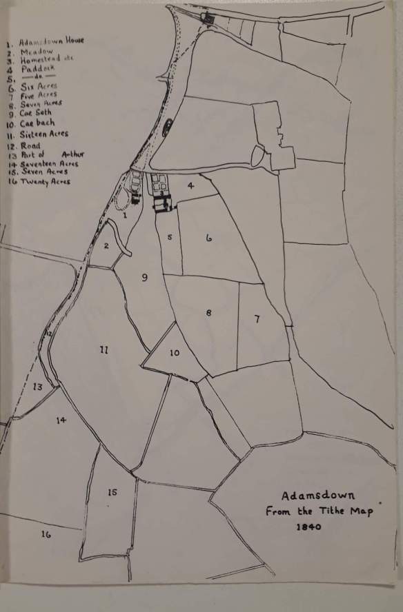
The homestead itself and most of the land was within the ecclesiastical parish of Roath. The earliest map is the Bute Estate plan of l824 – which shows the Adamsdown estate extending to the Bristol Channel in the south and including a strip of land running parallel with the parish boundary just within the eastern boundary of Cardiff; it also included a parcel of land in Cardiff bordered by the highway on the north and the plot on which the County gaol was built in 1839 – the Spital field.
The first mention of Adamsdown is in an Inquisition of 1440 following the deaths of Isabel le Despenser and her second husband, Richard Beauchamp, who as well as being Lord of Glamorgan was also Earl of Warwick. The name occurs again in a rental survey of 1492 of Jasper Tudor, Duke of Bedford, a document which provides a clue to the origin of the place name:-
“…8s. of the farm of 14 acres and one rood of land lying at Adamsdowne, lately occupied by the Gatekeeper of the Castle…
3s.8d. of the farm of 2 acres of meadow at Landesmede by Adamsdowne lately occupied by the Gatekeeper of the Castle aforesaid.
And for 13s.4d. of the farm of 15 acres of the said land called Adamscrofte, lately occupied by the aforesaid Gatekeeper…
…nevertheless now the said 3 parcels of land and meadow are demised to William Gough in approvement by the Receiver and Auditor, for that John Pawnton, Gatekeeper of the Castle aforesaid hath that office with the fees and wages unto the same office due and accustomed…”
Later in the same survey but under the heading ‘Farms with issues of the manor’, the following entry occurs:-
“And for 12d. of one acre and one rood of land at Adamesdowne lately demised unto John Coker, now demised to William Gough this year. And for l2d. of the farm of three roods of land lying in Adamesdowne aforesaid, so demised to the same William Gough this year”
Mention is also made of wagon loads of hay from the meadow there which had all disappeared at the time of the surveyor’s visit as the hay had all been consumed by the lord’s horses.
It should perhaps be explained that in the above translation of the Latin text, the word ‘firma’ has been rendered as ‘farm’. For all intents and purposes it is roughly equivalent to modern day ‘rent’.
From the above quoted documents it would be reasonable to assume that Adamsdown was traditionally a perquisite of the office of Gatekeeper (or Porter) of Cardiff Castle. J.Hobson Matthews surmised that the name originated from a certain Adam Kyngot, evidently the porter of the Castle mentioned in the Cardiff municipal charter of 1331. Whoever Adam was, the second element in the place-name indicates that it was his ‘down’.
The occasionally occurring version ‘Adamstown’ is a mis-spelling.
A survey of 1543 tells us that a certain Dio Roberts was paying 2d. rent for “one acre of meadow between the ditch and Adams Downe on the north side”. The same document later on refers to a ‘parcel of land called Adams Downe containing 11 acres’.
By the opening of the 17th century William Bawdripp of Splott acquired the house and lands of Richard Ivy,viz.50 acres of meadow and 30 acres of pasture at Adamsdown and numerous other closes in the vicinity claiming that Ivy had held them by lease from him.
In 1795 Henry Hollier moved from his residence at Cathays House to Adamsdown House. Hollier was chief agent of the first Marquess of Bute and John Davies in “Cardiff and the Marquesses of Bute” says “He had a lamentable record as estate agent. There is at least a suggestion that he swindled his employer. “He had been Town Clerk from 29 September 1786 to 5 March 1789. He was Clerk of the Peace for the County of Glamorgan, Collector of H.M.Customs and Receiver General of Taxes.
His public career ended in ignominy when having defrauded the Treasury his landed estate was forfeit to the Crown and sold. He was removed from office of Alderman of Cardiff in 1818 for “bad government”.
His residence was acquired by the first Marquess of Bute in 1811 although both Hollier and his son Henry Hollier (junior) appear to have continued in residence there for some years after that.

By 1841 Adamsdown House and Adamsdown Farm were separate tenancies. The house and its grounds, comprising 4% acres was then occupied by Whitlock Nichol Esq. He had been a widower for 20 years and lived in the house with his two sons and his elder brother,Edward. The Nichols were one of the illustrious families of Glamorgan. Whitlock died in 1855 (his wife had died in 1855) but his son Frederick Vincent continued to live at Adamsdown until his death in 1855. The house later became a ladies’ boarding school run by Miss Martha Vaughan, who had previously had a school at 49 Crockherbtown, Cardiff. The building is described by J.Hobson Matthews as a slated house with yard and extensive barns and outbuildings at the west end of the railway line near the wooden bridge where now is Adamsdown Square. It was demolished c.1875.
Meanwhile the adjoining Adamsdown Farm comprising a homestead, paddock and land of 270½ acres (including 21 acres on Splott Moors) had been leased from Bute in 1841 by William and William Alexander Bradley of the well known Cardiff family. At the time of the census in that year it was occupied by the farm steward, James Gabb and his family and an eighty year old labourer, Edward Williams. Soon afterwards George Roberts came into occupation of the farm. In 1851 he was farming 220 acres of upland and 46 of moor. The census return shows that he was born at the village of Corwen, Mongomeryshire but that his son Edward was born c.1829 at Llandyssul in Cardiganshire. That George Roberts was a man of some social status in Roath is evidenced by the fact that he qualified for enfranchisement by virtue of his occupation of the lands at Adamsdown from 1845 until his death on the 5th April 1868 at the age of 76. A directory of 1855 shows him to be churchwarden jointly with Charles Croft Williams of Roath Court. The same directory also refers to William Williams as farming at Adamsdown.

The South Wales Railway (later the Great Western Railway) sliced through the Adamsdown estate so that the only access to the lands from the farmhouse was by way of a footbridge over the railway line. The railway had been completed by 1850 but 19 years later Waring’s map shows no street development south of the railway other than a small rectangle of dwellings adjacent to the railway line described as “Adamsdown Cottages”, while immediately south of this site is a rectangle captioned “intended new streets”. In fact no new streets were ever built on the site, the Bute agents evidently considering it more remunerative to lease the land for the use of saw mills and timber yards, which exist there to this day (1983) on the south side of Sanquahar Street. When the old Adamsdown Farm was demolished to make room for street development, a new farmstead was built to the east of the timber yards, its exact location being given by J.Hobson Matthews as 48 Sanquahar Street, East Moors.
Rather confusingly, this site is shown on the 1878/9 O.S.6″ Survey as Adamsdown House”. By that date the new Adamsdown Farm was becoming a farm-house without a farm because of the industrialisation of Adamsdown land on the East Moors. A directory of 1895 tells us that Edward Roberts was still there and his occupation is given as a farmer.
The East Moors is not today regarded as being part of Adamsdown, but historically, it was part of the vast Adamsdown estate of the Butes.
The Bute East Dock had been completed in 1859 and the land lying to the east and south-east of the dock was ideally suited for industrial development. The full story of the rise and fall of the greatest industrial estate in Cardiff must be told elsewhere. It and the most momentous event of all- the arrival of the Dowlais Iron Co which started operating there in 1891.
Five years later steel production commenced and in 1901 the company was taken over by Guest Keen and Co. which amalgamated the following year to form Guest Keen & Nettlefolds Ltd. Recessions, changes in demand, new processes and inadequate dock facilities all contributed to take their toll. Steel making came to a halt in 1934 and a completely new plant was commissioned in 1936.

Then followed nationalisation in 1951, de-nationalisation in 1954 and re-nationalisation in 1967. Despite the £9 million capital expansion project completed by 1964, production finally ceased on 28 April 1978.
Today, clearance of the site has been completed and a modern type industrial estate is taking shape. Gone forever is the old familiar skyline of chimneys, cranes, gasometers and sheds.
As for housing development, the Bute Estate laid out a grid of short streets of small terraced houses in the 1880’s and 1890’s on the north side of Sanquahar Street on the site of the old Adamsdown Cottages between the timber yards and the railway line with street names culled from the almost interminable string of titles of the Marquess of Bute, his family and his Scottish estates. The houses were owned by the Cardiff Cottage Company which had been formed in 1869 and operated by borrowing money from the Public Works Loan Commissioners at 4% p.a. to finance the purchase of the houses which were then rented out for weekly amounts within the means of the artisan class community.
The most extensive housing project however was that of the Dowlais Iron Co. which on the spare land leased from the Bute estate adjoining the iron works built cottages for their workmen. Along this narrow strip of about ten acres stretching towards the foreshore the area which came to be known as Lower Splott sprang up in the late 1880’s and early 1890’s. Here were Elaine St, Cornelia St, Enid St, Layard St, Swansea St, Menelaus St and Portmanmoor Road. A new iron church dedicated to St.Francis was opened in the district on December 10th 1889.
The whole area was demolished by the Cardiff City Council, over a period in the mid-1960’s. The portion of Adamsdown on the north side of the railway line was urbanised in the 1870’s, beginning with the building of a Board School in Adamsdown Square in 1875. House plans were being submitted in October 1876 for Galston Street and West Luton Place. A small grid of streets arose between the railway line and Constellation Street – Garesfield St. Galston St, Galston Place, Prince Leopold St and Kames St. The first house plans for Adamsdown Square were approved in January 1877. This area was populated mostly by manual wage earners employed on the railways or docks. Adamsdown Square was one of many gardens and squares in Cardiff handed over in 1888 to the Cardiff Corporation and was in keeping with Bute policy to enhance the ground-rent value of the surrounding leasehold properties.
Today, Adamsdown is in a state of decline. It’s church, All Saints, in Adamsdown Square is used as a warehouse. The old Adamsdown cemetery, once the churchyard of St.Mary’s, Cardiff has been desecrated. A strong working class community spirit still persists and finds expression through the local Community Trust, while a local housing association has made brave efforts to renovate some of the houses.
In the words of a publication by the Adamsdown Community Trust “Adam’s down but not out”.
